Saskatchewan One Room School Project provides an online history for current generations to enjoy, preserve, and experience, our historical educational, architectural, and cultural, heritage.

Cupar and District Heritage Museum One Room Schoolhouse Photos
South East area of the province of Saskatchewan (SK), Canada (CA)


SCHOOL
NAME
School
District #
OPENING CLOSURE MAP SHEET QUARTER SECTION TOWNSHIP RANGE MERIDIAN NEAR DATE OF PHOTO NOTES
APPONYI 1230 1912 1914 Touchwood Sheet Map SE 3 Township 26 Range 17 W of the 2 nd Meridian near or in Arbury   Later Named ARBURY. Arbury P.O. SE Section 27 Tsp 25 Rge 17 W2 Footnotes  
ARBURY 1230 1914   Touchwood Sheet Map SE 3 Township 26 Range 17 W of the 2 nd Meridian near or in Arbury 1948 Previously named APPONYI. Arbury P.O. SE Section 27 Tsp 25 Rge 17 W2 Footnotes  
ARPAD 2538 1910 org 1911 classes 1959 Yorkton - Touchwood Hills Sheets Map SW of SE 29 Township 25 Range 15 W of the 2 nd Meridian near Lestock 1949 Footnotes   on four acres of land
BALROBIE 2353 1909 1957 Qu'Appelle Sheet Map NW 34 Township 23 Range 14 W of the 2 nd Meridian near Lipton 1948 Closed June 1957, Conveyed to Lipton.   Footnotes
BERESFORD 1886 1907 1960 Yorkton, Qu'Appelle Sheets Map SE of SE 16 Township 25 Range 13 W of the 2 nd Meridian near Garnock / Kelliher 1949 Footnotes  
BIMBO 3288 1914 1960 Yorkton Sheet Map NE 13 Township 26 Range 16 W of the 2 nd Meridian near Lestock 1948 Replaced 1950. Footnotes  
BOURNEVILLE 3521 1915 1950 Regina Sheet Map SW of NW 2 Township 24 Range 19 W of the 2 nd Meridian near Southey 1951 Remodelled 1951  
BRYN MAWR (A) 3312 1914 1952 Regina Sheet Map SE of SE 29 Township 24 Range 19 W of the 2 nd Meridian near Southey / Bulyea 1949 One room schoolhouse at this site. COTSWOLD was the name of the district before BRYN MAWR selected for schoolhouse and district name. BRYN MAWR SD 3312  
BRYN MAWR ( (B) CENTRALIZED SCHOOL 1952 1968 Regina Sheet Map SE 15 Township 24 Range 19 W of the 2 nd Meridian near Southey / Bulyea 1952 Centralized 1951. New 1956. BRYN MAWR SD 3312  
BURNSIDE 2146 1908   Regina Sheet Map NE 9 Township 21 Range 20 W of the 2 nd Meridian near Glenbrea / Long Lake 1947 AND 1952 Rebuilt 1951. Footnotes  
BUTTERTON 3729 1916 1956 Regina Sheet Map SE 15 Township 24 Range 20 W of the 2 nd Meridian near Bulyea/ Earl Grey 1947 AND 1952 Rebuilt 1951. BUTTERTON SD 3729 LAST MOUNTAIN VALLEY / STRASSBURG SD 92 -a neighbouring school to BUTTERTON  
CAMPBELLTOWN 2297 1909 1959 Yorkton Sheet Map SW of SW 3 Township 27 Range 12 W of the 2 nd Meridian near Kelliher 1950 and 1954 Remodelled with basement 1953. CAMPBELLTON SD 2297 another spelling. Footnotes  
CANTERBURY 3345 1914 1960 Qu'Appelle Sheet Map SW 17 Township 23 Range 14 W of the 2 nd Meridian near Lipton 1949  
CAVENDISH 3841 1916 1959 Touchwood Hills Sheet Map NE 1 Township 26 Range 18 W of the 2 nd Meridian near Arbury 1947  
COLLEGIATE CUPAR       Regina Sheet Map (village school)   Township 23 Range 16 W of the 2 nd Meridian in Cupar     Photo 2
CORNWALL (A) 698 1902 Class 1903 1918 Regina Sheet Map SE 28 Township 21 Range 19 W of the 2 nd Meridian near Fairy Hill    
CORNWALL (B) 698 1918 1959 Regina Sheet Map NW of SE 34 Township 21 Range 19 W of the 2 nd Meridian near Fairy Hill 1950 New building 1958 - old CRAIGILEA school moved to CORNWALL.  
COYNACH 3360 1914 classes 1915 1952 Regina Sheet Map SE of SE 13 Township 24 Range 18 W of the 2 nd Meridian near Southey 1948 Conveyed 1951-Closed. Location also given as SE 13-19-24 in text. Map coordinates shown in table.  
CRAIGILEE (CRAIGILEA) 5062 1934 1950 None Map NE of NE 32 Township 21 Range 18 W of the 2 nd Meridian near Southey 1947 Closed - conveyed 1951. Building moved to CORNWALL.  
CUPAR HIGH SCHOOL       Regina Sheet Map (village school)   Township 23 Range 16 W of the 2 nd Meridian in Cupar   Second photo  
CUPAR PUBLIC SCHOOL 972 1904   Regina Sheet Map (village school) 12 Township 23 Range 17 W of the 2 nd Meridian in Cupar public school Old school-teacherage photo 2 Public and High school 2 Moved into village in 1907. In 1935 Footnotes  
Cupar School Division 28                 in Cupar    
DALRYMPLE 524 1901 1949 Regina Sheet Map SE 21 Township 22 Range 16 W of the 2 nd Meridian near Cupar   Footnotes  
DELLWOOD 4668 1926 1956 None Map NE 35 Township 22 Range 16 W of the 2 nd Meridian near Cupar   Footnotes  
DOVERLEY 2794 1911 1959 Yorkton Sheet Map SE 15 Township 26 Range 14 W of the 2 nd Meridian near Leross 1946 and 1947 Building replaced 1947. DOVERLEY SD 2794  
DYSART 1449 1905 1960 Qu'Appelle Sheet Map     Township 23 Range 15 W of the 2 nd Meridian in or near Dysart 1949 Dysart P.O. NE Section 9 Tsp 23 Rge 15 W2 Dysart and District museum school photos  
EARL GREY 1240 1909 1932 Regina Sheet Map (village school)   Township 23 Range 20 W of the 2 nd Meridian in Earl Grey 1949 Earl Grey P.O. SE Section 10 Tsp 23 Rge 20 W2  
EASTMOUNT 1715   1956 Regina Sheet Map SE 18 Township 24 Range 20 W of the 2 nd Meridian near Butterton 1952 Closed 1956, conveyed to Bryn Mawr.  
EASTWARD 1477 1907 1962 Yorkton Sheet Map NE 21 Township 27 Range 12 W of the 2 nd Meridian near Kelliher 1950 Footnotes  
ENID 381 1912 1912 Yorkton -Qu'Appelle Sheets Map SE 23 Township 25 Range 15 W of the 2 nd Meridian near Dysart / Lipton   First name of MILLERSDALE SD 381   Footnotes
ESKDALE 1628 1906 1959 Yorkton - Qu'Appelle Sheets Map NE 22 Township 25 Range 14 W of the 2 nd Meridian near Leross / Crosthwaite 1949  
FOSTERDALE 3623     NONE Map     Township 22 Range 21 W of the 2 nd Meridian near Gibbs 1949 Gibbs P.O. NW 28-22-21-W2   Also recorded as FOSTERDALE SD 3723 see note below.
FOX HILLS 190 1910 Org. 1912 Classes. 1953 Regina / Qu'Appelle Sheets Map SW of SE 14 Township 24 Range 16 W of the 2 nd Meridian near Fox Hills   P.O. SE Section 14 Tsp 24 Rge 16 W2   Footnotes Class Photo 1915
FRANSFIELD 2031 1908 1962 Regina Sheet Map NW of NW 21 Township 22 Range 19 W of the 2 nd Meridian near Southey 1948 and 1950 Rebuilt 1950. The district name of KÖNUGSBURG was already being used, before the school built, FRANSFIELD decided upon  
FREELAND 4108 1918   None Map     Township 24 Range 14 W of the 2 nd Meridian near Headlands / Lipton 1949 FREELAND on SK One Room School Project Footnotes  
FREUDENTHAL 1309 1905 class 1907 before 1960 Regina Sheet Map NW of NW 9 Township 23 Range 19 W of the 2 nd Meridian near Southey / Earl Grey 1947 FRIEDENTHAL SD3384 SE Section 24 Tsp 14 Rge 15 W2 near Sedley  
GARDINER 3428 1914 1960 Qu'Appelle Sheet Map SW 4 Township 24 Range 15 W of the 2 nd Meridian near Dysart 1951 GARDINER SD 3428   Gardiner SD 3428
GARNOCK 2227 1909 1960 Yorkton Shet Map     Township 26 Range 13 W of the 2 nd Meridian near Kelliher / Garnock 1948 and 1954 Replaced 1950.   Footnotes ST JOSEH DE DAUPHINAIS SD 317 - neighbouring school
GEORGES 1386 1905 1952 Yorkton Sheet Map NE 31 Township 25 Range 14 W of the 2 nd Meridian near Benchonzie / Leross / Lestock 1948 Closed 1952, Conveyed. Building moved to Campbelltown for teacherage 1953.   Footnotes
GRANATIER 1497 1907 1959 Yorkton Sheet Map NW 12 Township 26 Range 15 W of the 2 nd Meridian near Leross / Lestock 1948 Building 1950. Building sold to United Church Eskdale. GRANATIER SD 1497 National Heritage Site Granatier SD 1497   Granatier SD 1497
GREGHERD 3142 1913 1958 Regina Sheet Map NW 32 Township 24 Range 17 W of the 2 nd Meridian near Gregherd 1948 and 1954 1954 Porch added. P.O. NE Section 32 Tsp 24 Rge 18 W2 R.M. Cupar 218 GREGHERD Historical Site  
HAYWARD 845 1904 1959 Qu'Appelle Sheet Map NE 7 Township 23 Range 13 W of the 2 nd Meridian near Hayward 1949 and 1952 Replaced 1952. P.O. SE Section 32 Tsp 22 Rge 13 W2 HAYWARD SD National Heritage Site Hayward School on SK One Room School Project CUPAR R.M. 217 Hayward Heritage Site Footnotes  
HAZELWOOD 2814 1911 classes 1912 1958 Regina - Touchwood Hills Sheets Map NE of NW 35 Township 24 Range 18 W of the 2 nd Meridian near Hazelwood 1948 and 1952 Replaced 1950. P.O. NE Section 24 Tsp 11 Rge 5 W2  
HEADLANDS (A) 4012 1919 1924 None Map NW 34 Township 24 Range 14 w of the 2 nd Meridian near Headlands 1948 and 1952 P.O. SW Section 32 Tsp 24 Rge 13 W2 Headlands SD 4012  
HEADLANDS S (B) 4012 1924 1959 None Map NE 34 Township 24 Range 14 w of the 2 nd Meridian near Headlands 1948 and 1952 P.O. SW Section 32 Tsp 24 Rge 13 W2 Headlands SD 4012   Footnotes
HERZEL 1503 1906 1959 None Map SW 30 Township 23 Range 12 W of the 2 nd Meridian near Hirzel and Herzel 1949 Closed 1949. Rebuilt, and reopened 1954. P.O. SW Sec 6 Tsp 24 Rge 8 W2   Footnotes
JASMIN 2078 1908 1975 Yorkton Sheet Map SE 8 Township 26 Range 12 W of the 2 nd Meridian near Jasmin 1949 P.O. SW Section 9 Tsp 26 Rge 12 W2 JASMINE SD Footnotes  
JOHNSON 611 1912 1962 Yorkton Sheet Map NW of SW 35 Township 27 Range 13 W of the 2 nd Meridian near Kelliher 1949 Footnotes  
JESHURUN (Joshurun) 1913 1907 1952 Qu'Appelle Sheet Map NW 22 Township 22 Range 13 W of the 2 nd Meridian near Lipton 1948   Footnotes
KAHLSBERG 1950     Regina Sheet Map     Township 23,24 Range 20 W of the 2 nd Meridian near Butterton, Earl Grey 1948 Rebuilt 1951  
KALUZIK unknown c1914 SW Township Range   1914 news As this is a proposed name without SD#, not much is known about dates/location  
KELLIHER 2254 1909   Yorkton Sheet Map (village school)   Township 26 Range 13 W of the 2 nd Meridian in Kelliher 1949 P.O. NW Section 34 Tsp 26 Rge 13 W2 Cottage School Added 1953   Footnotes
KILSHANNIG 786 1912 1957 Regina Sheet Map SW 28 Township 21 Range 16 W of the 2 nd Meridian near Cupar / Loon Creek 1950   Footnotes Photo 2
KING (A) 738 1912 1934 Regina Sheet Map     Township 22 Range 17,18 W of the 2 nd Meridian near Wheatwyn 1949 First school had a gable pitched roof. Karl King homesteaded SE 32-22-18-W2  
KING (B) 738 1934 1956 Regina Sheet Map     Township 22 Range 17,18 W of the 2 nd Meridian near Wheatwyn 1949 Second school had a hip style roof. Closed 1956 - Conveyed to Markinch.  
KINGSVILLE 2288 1909 Class 1910 c1952 Regina Sheet Map SW of SW 18 Township 22 Range 18 W of the 2 nd Meridian near Southey 1949 Before school was built HILBOKA (From 1908), then KONIGSBURY (From Dec. 1908) were the local names of the area.  
LEROSS 2274     Yorkton Sheet Map (village school)   Township 27 Range 14 W of the 2 nd Meridian in Leross 1949 P.O. SE Section 11 Tsp 27A Rge 14 W2  
LESTOCK 2919     Yorkton Sheet Map (village school)   Township 27 Range 14 W of the 2 nd Meridian in Lestock 1948 New School 1953. P.O. NW Section 6 Tsp 27 Rge 14 W2   Footnotes
LESTOCK Consolidated     Yorkton Sheet Map (village school)   Township 27 Range 14 W of the 2 nd Meridian in Lestock 1954 Lestock Consolidated. P.O. NW Section 6 Tsp 27 Rge 14 W2   Footnotes
LIPTON 1347     Qu'Appelle Sheet Map (village school)   Township 22 Range 14 W of the 2 nd Meridian in Lipton 1949 Cottage School added 1953. P.O. NW Section 26 Tsp 22 Rge 14 W2   Footnotes
LOON CREEK 868 1903 Org. 1904 Classes. 1958 Regina Map   35 Township 21 Range 17 W of the 2 nd Meridian near Loon Creek   P.O. SW Section 18 Tsp 22 Rge 17 W2 The School house location given is for the second school located north of the original school site; second school built 1923.   Footnotes Photo 2
LUPESCU 3146 1913 1948 Qu'Appelle Map SW 30 Township 24 Range 19 W of the 2 nd Meridian near Cupar / McDonald Hills 1914 news Later name PRINCESS ELIZABETH SD 3146 Footnotes  
MARIGOLD 4807 1931 1953 None Map     Township 25 Range 16 W of the 2 nd Meridian near Marigold / Cupar / South Touchwood     Footnotes
MARKINCH CON 1880     Regina Sheet Map     Township 23 Range 18 W of the 2 nd Meridian near Markinch 1949 P.O. SE Section 7 Tsp 23 Rge 17 W2  
MARLOW 3717 1916 1957 Yorkton Sheet Map NE 31 Township 27 Range 14 W of the 2 nd Meridian near Lestock 1949 Conveyed to Lestock 1957.   Footnotes
MARR HALL 1879 1907 1959 Touchwood Sheet Map SW 3 Township 26 Range 16 W of the 2 nd Meridian near Arbury / South Touchwood / Lestock 1950   Footnotes
MATHYAS 3141     Touchwood Sheet Map SW 21 Township 17 Range 25 w of the 2 nd Meridian near Arbury / Punnichy 1948   Footnotes
MCDONALD HILLS 1646 1906 1947 Qu'Appelle Sheet Map NE 33 Township 24 Range 15 W of the 2 nd Meridian near McDonald Hills 1947 P.O. SW Section 5 Tsp 25 Rge 15 W2 School replaced 1948  
MILLERSDALE 381 1912 1959 Yorkton -Qu'Appelle Sheets Map SE 23 Township 25 Range 15 W of the 2 nd Meridian near Crosthwaite / Magyar     Repaired 1950. Burned and Replaced. Footnotes
NEW HAVEN 1970 1908 1962 Yorkton Sheet Map SE 11 Township 27 Range 13 W of the 2 nd Meridian near Kelliher 1948   Footnotes
PARKLANDS (A) 268 1893   None Map NE 20 Township 22 Range 14 W of the 2 nd Meridian near Parklands   P.O. NW Section 20 Tsp 22 Rge 14 W2  
PARKLANDS (B) 268   1960 None Map NE 24 Township 22 Range 15 W of the 2 nd Meridian near Parklands 1948 Not sure if this photo is of school A or B. P.O. NW Section 20 Tsp 22 Rge 14 W2   Footnotes
POPLAR PEAK 4876 1931 1959 None Map     Township Range of the nd Meridian near Lestock 1950   Footnotes
PRINCESS ELIZABETH 3146 1913 1948 Qu'Appelle Map SW 30 Township 24 Range 19 W of the 2 nd Meridian near Cupar / McDonald Hills   Previous Name LUPESCU SD 3146  
RADANT 3474 1915 1960 Regina Sheet Map NW 17 Township 22 Range 15 W of the 2 nd Meridian near Dysart / McDonald Hills 1947 Replaced 1950  
RAVINE 355     Yorkton Sheet Map     Township 27 Range 13,14 W of the 2 nd Meridian near Touchwood Hills , Horse Lake 1947 Replaced -  
REINDEER 1442 1935 1960 Qu'Appelle Sheet Map SE 13 Township 23 Range 13 W of the 2 nd Meridian near Tullymet / Lipton 1948 Footnotes Current sign   Previous Name TIFERES ISRAEL
SAMBOR 4057 1914 1960 Qu'Appelle Sheet Map SE 36 Township 23 Range 15 W of the 2 nd Meridian near Dysart   Dysart and District museum school photos   Footnotes
SCARBOROUGH 1804 1907   Regina Sheet Map NW 6 Township 22 Range 20 W of the 2 nd Meridian near Earl Grey / Long Lake 1947   Footnotes
SHAWLANDS 2161 1908 1959 Qu'Appelle Sheet Map NE 21 Township 24 Range 13 W of the 2 nd Meridian near Headlands 1948 and 1952 Replaced 1949   Footnotes
SNARUM 1262 1905 1952 Regina Sheet Map NE of NW 33 Township 23 Range 19 W of the 2 nd Meridian near Southey 1950 Conveyed 1951  
SOUTHEY 1617 1905   Regina Sheet Map SW 7 Township 23 Range 19 W of the 2 nd Meridian in Southey   P.O. SE Section 7 Tsp 23 Rge 18 W2  
ST. IMRE 1233 1913 Org. 1915 Classes.   Regina Sheet Map SW 11 Township 25 Range 16 W of the 2 nd Meridian near Cupar 1950   Footnotes St. Imre SD 1233 Photo 2

SUNNY NORTH 2515 1910 1959 Regina Sheet Map SE of NE 25 Township 23 Range 19 W of the 2 nd Meridian near Southey 1948 Replaced 1955. Remodelled 1955.  
TIFERES ISRAEL (A) 1442 1906 1919 Qu'Appelle Sheet Map NE 12 Township 23 Range 13 W of the 2 nd Meridian near Tullymet / Lipton   Later Name REINDEER   Current sign
TIFERES ISRAEL (B) 1442 1919 1935 Qu'Appelle Sheet Map SE 13 Township 23 Range 13 W of the 2 nd Meridian near Tullymet / Lipton   Later Name REINDEER   Current sign
TOUCHWOOD HILLS (A) 444 1897 1905 Yorkton Sheet Map SE 28 Township 27 Range 15 W of the 2 nd Meridian near Touchwood   P.O. Section 23 Tsp 27 Rge 16 W2 Footnotes  
TOUCHWOOD HILLS (B) 444 1920 1931 Yorkton Sheet Map SE 28 Township 27 Range 15 W of the 2 nd Meridian near Touchwood   P.O. Section 23 Tsp 27 Rge 16 W2 Footnotes  
TOUCHWOOD HILLS (C) 444 1932 1959 Yorkton Sheet Map SE 32 Township 27 Range 15 W of the 2 nd Meridian near Touchwood 1949 P.O. Section 23 Tsp 27 Rge 16 W2 Footnotes  
VIRAG 2158 1908 1960 Yorkton Sheet Map NE 33 Township 26 Range 15 W of the 2 nd Meridian near Lestock 1949  
WESTLEA 4356 1919 1920 None Map NE 33 Township 24,25 Range 14,15 W of the 2 nd Meridian near Dysart    
WESTLEA 4356 1921 1960 None Map SE of NE 25 Township 24 Range 15 W of the 2 nd Meridian near Dysart 1949 Porch 1954  
WHEATWYN (A) 1169 1905   Regina Sheet Map SE 35 Township 21 Range 18 W of the 2 nd Meridian near Wheatwyn 1950 P.O. NE Section 2 Tsp 22 Rge 18 W2  
WHEATWYN (B) 1169     Regina Sheet Map     Township 21,22 Range 17,18 W of the 2 nd Meridian near Wheatwyn 1950 Second school was a two room building.  
WILEY 2340 1909 1957 Regina Sheet Map SE 8 Township 24 Range 17 W of the 2 nd Meridian near Markinch 1949  
Other images of Cupar School Unit 28
Note a school name followed by a letter means that the school house changed locations, but the school name remained the same. This change often happened if the school boundaries were altered or if the student population in the area changed when a new schoolhouse was required.
P.O. = Post office CH = Cupar Herald newspaper clippings followed by the date, and subject.
Note: FOSTERDALE SD 3623 has also been found recorded as FOSTERDALE SD 3723
ST JUDE SD 3723 SECTION 27 TSP 43 RGE 26 W2, which also bears the SD number 3723 has been recorded in the following book. A Land Harvested By Faith 1884-1994 , Wakaw Published Wakaw, Sask. Wakaw Heritage Society, 1984. ISBN 0889255458 (corrected)
ALAMAC SD 4465 at SE 6 Tsp 53 Rge 21 W3 changed names to SPRUCE LAKE. SPRUCE LAKE SD 3623 has been recorded at Tsp 52 Rge 21 W3 near Emmaville and also bears the SD number of 3623
The handwritten listing by the Department of Education transcribed online lists FOSTERDALE School District # 3623, SPRUCE LAKE School District # 4465, and ST. JUDE School District # 3723.

Cupar Town Location 8-23-16-W2
Province Saskatchewan
Latitude - Longitude DMS 50° 56' 48" N, 104° 12' 39'' W
Latitude - Longitude (decimal) 50.9466583, -104.2109556

School District Map for these schools

1924 Railway Map for these place names; Township 20-27, Range 12-20, West of the Second Meridian

Nearby placenames which surround Cupar and District Heritage Museum
and the aforementioned 89 School Districts::


Placename Designation       Section Township Range Meridian P.O. Date MAP SHEET
Abernethy Village       25 20 11 W2 1904 Qu'Appelle Sheet
Arbury Post Office       2 26 17 W2 1907-1914 Touchwood Hills Sheet
Arbury Post Office       36 25 17 W2 1917-1920 Touchwood Hills Sheet
Arbury Unincorporated area   SE   27 25 17 W2 1926-1969 Touchwood Hills Sheet
Arbury Post Office   SW   20 25 17 W2   Touchwood Hills Sheet
Avonhurst Post Office       2 20 16 W2 1900-moved into store Regina Sheet
Avonhurst Unincorporated area       26 19 16 W2 store Regina Sheet
Balcarres Town       13 21 12 W2   Qu'Appelle Sheet
Beckenham No Longer       32 27 11 W2   Yorkton Sheet
Benchonzie No longer       28 26 14 W2   Yorkton Sheet
Blackwood Unincorporated area       1 19 11 W2 1884-1964 Qu'Appelle Sheet
Booth Unincorporated area       21 28 19 W2   Touchwood Hills Sheet
Brora Unincorporated area       3 19 20 W2   Regina Sheet
B-Say-Tah Village       23 21 14 W2   Qu'Appelle Sheet
Bulyea Post Office       36 16 21 W2 1900-1905 Regina Sheet
Bulyea Village       27 23 21 W2 1905- Regina Sheet
Bunglass No Longer       2 25 12 W2   Yorkton Sheet
Butterton Post Office       15 24 20 W2 1906- Regina Sheet
Butterton Unincorporated area       31 24 19 W2   Regina Sheet
Clapton Post Office       30 25 20 W2 1908- Touchwood Hills Sheet
Clapton No Longer       6 26 20 W2 1914- Touchwood Hills Sheet
Cotton No Longer       27 21 12 W2   Yorkton Sheet
Craven Village       23 20 21 W2 1884- Regina Sheet
Crosswoods No Longer       22 25 18 W2   Touchwood Hills Sheet
Crosthwaite No longer       32 25 14 W2   Yorkton Sheet
Crowtherview No Longer       32 27 9 W2 Later named Parkerview Yorkton Sheet
Cupar Post Office       36 22 17 W2 1903- Regina Sheet
Cupar Town       8 23 16 W2 1905- Regina Sheet
Deer Valley Unincorporated area       8 19 21 W2   Regina Sheet
Dysart Village       9 23 15 W2 1906- Regina Sheet
Earl Grey Village       10 23 20 W2 1905- Regina Sheet
Edenwold Village       26 19 17 W2   Regina Sheet
Edgeley Hamlet       27 19 15 W2   Regina Sheet
Elbourne Unincorporated area       20 25 19 W2   Touchwood Hills Sheet
Enid Post Office   SW   125 25 15 W2 1909- Yorkton Sheet
Enid Unincorporated area       18 25 14 W2   Yorkton Sheet
Fairy Hill Unincorporated area       27 21 19 W2   Regina Sheet
Fort Qu'Appelle Town       7 21 13 W2   Qu'Appelle Sheet
Fort San Village       18,24,26 21 13,14 W2   Qu'Appelle Sheet
Fox Hills Unincorporated area       14 24 16 W2   Regina Sheet
Fox Leigh No Longer       13 19 19 W2   Regina Sheet
Franks Lake No Longer       12 19 18 W2   Regina Sheet
Frankslake Unincorporated area       18 19 17 W2   Regina Sheet
Gibbs Unincorporated area       28 22 21 W2   Regina Sheet
Gillespie Unincorporated area       24 21 11 W2   Qu'Appelle Sheet
Gladwin No Longer       12 27 9 w2   Yorkton Sheet
Glenbrea Unincorporated area       17 21 20 W2   Regina Sheet
Gregherd Unincorporated area       32 24 18 W2   Regina Sheet
Headlands Post Office       34 24 14 W2 1904- Qu'Appelle Sheet
Headlands No longer       32 24 13 W2   Qu'Appelle Sheet
Herzel Unincorporated area       30 23 12 W2   Qu'Appelle Sheet
Horse Lake No Longer       32 27 12 W2   Yorkton Sheet
Hugonard Unincorporated area       15 21 12 W2   Qu'Appelle Sheet
Ituna Town       21 25 11 W2   Yorkton Sheet
Jasmin Unincorporated area       9 26 12 W2   Yorkton Sheet
Kannata Valley Village       18 21 21 W2   Regina Sheet
Katepwa Beach Village       9 20 12 W2   Qu'Appelle Sheet
Katepwa South Village       32 19 12 W2   Qu'Appelle Sheet
Kelliher Village       34 26 13 W2   Yorkton Sheet
Kenlis Unincorporated area       27 19 11 W2   Qu'Appelle Sheet
Kennell Unincorporated area       30 20 19 W2   Regina Sheet
Lake View Beach Unincorporated area       8 20 12 W2   Qu'Appelle Sheet
Last Mountain Unincorporated area       3 26 20 W2   Touchwood Hills Sheet
Lebret Village       2 21 13 W2   Qu'Appelle Sheet
Leross Village       11 27A 14 W2   Yorkton Sheet
Lestock Village       6 27 14 W2   Yorkton Sheet
Lipton Village       26 22 14 W2   Qu'Appelle Sheet
Loon Creek Post Office       6 22 17 W2 1884- Regina Sheet
Loon Creek No Longer       18 21 17 W2   Regina Sheet
Lumsden Town       33 19 21 W2   Regina Sheet
Lumsden Beach Village       7 21 21 W2   Regina Sheet
Magyar Unincorporated area       2 26 16 W2   Touchwood Hills Sheet
Markinch Village       7 23 17 W2   Regina Sheet
McDonald Hills Post Office       14 24 15 W2 1896-then moved to store Touchwood Hills Sheet
McDonald Hills Unincorporated area       5 25 15 W2   Touchwood Hills Sheet
Mostyn No longer       6 27 14 W2   Yorkton Sheet
Muscow Unincorporated area       32 20 14 W2   Qu'Appelle Sheet
Oncree No Longer       9 23 17 W2   Regina Sheet
Parkerview No Longer       32 27 9 W2 Previously named Crowtherview Yorkton Sheet
Patrick Unincorporated area       11 22 13 W2   Qu'Appelle Sheet
Punnichy Village       2 28 17 W2   Touchwood Hills Sheet
Quinton Village       12 28 18 W2   Touchwood Hills Sheet
Raymore Town       19 28 18 W2   Touchwood Hills Sheet
Sandy Beach Village       17 20 12 W2   Qu'Appelle Sheet
Semans Village       22 28 20 W2   Touchwood Hills Sheet
Serath Unincorporated area       36 25 19 W2   Touchwood Hills Sheet
Silton Village       30 21 21 W2   Regina Sheet
South Touchwood Unincorporated area       13 25 16 W2   Touchwood Hills Sheet
Southey Town       7 23 18 W2   Regina Sheet
Strathcarrol No Longer       19 13 W2   Qu'Appelle Sheet
Tate Unincorporated area       36 28 21 W2   Touchwood Hills Sheet
Taylor Beach Hamlet       8 20 12 W2   Qu'Appelle Sheet
Tregarva Unincorporated area       16 19 20 W2   Regina Sheet
Valeport Unincorporated area       33 20 21 W2   Regina Sheet
Valleyview No Longer       22 21 16 w2   Regina Sheet
Westmoor No longer       12 28 15 W2   Touchwood Hills Sheet
Wheatwyn       20 25 16 W2   Touchwood Hills Sheet
Winthorpe Unincorporated area       23 28 11 W2   Yorkton Sheet
Wynot Unincorporated area       30 28 14 W2   Yorkton Sheet
Zala Unincorporated area       20 25 16 W2   Touchwood Hills Sheet
According to the "Atlas of Saskatchewan - Celebrating the Millenium Edition" edited by Ka-iu Fung, a city has a population over 5,000, towns over 500, villages more than 100, organized hamlets fewer than 100, and finally a locality has fewer than 10. An unincorporated area includes hamlets, localities, resorts, post offices, and railway points. Some place names may only exist as historical settlements of the districts.
On the early maps, locations of the early settlement around the post office (P.O.) may be marked rather than the current village location.

84

RURAL MUNICIPALITIES in the area:
RMs began as areas encompassing nine townships, and were 18 miles square. With population fluctuations, survey allowances for earth curvature and naturally occuring geographical accomodations such as rivers, the boundaries have altered. RM 248, 247, 217 and 218 are still approximately nine townships in size.RM 218 does extend down to the South Saskatchewan River. as does RM 219. RM 189 extends north to the river. RM 279 is irregularly shaped and takes in the largest area.
MOUNT HOPE RM 279TOUCHWOOD RM 248KELLROSS RM 247
LONGLAKETON RM 219CUPAR RM 218LIPTON RM 217
LUMSDEN RM 189EDENWOLD RM 158NORTH QU'APPELLE RM 187
 
NORTH 
WEST  
EAST
 
SOUTH  
  • RM 279
    Tsp. part 25, 26, 27, 28, 29, 30
    Rge 16, 17 18 19 20 21
  • RM 248
    Tsp 25, 26, 27
    Rge 16, 17, 18
  • RM 247Tsp 25, 26 27
    Rge 13, 14, 15
  • RM 219
    Tsp part 20, 21 22, 23 24, part 25
    Rge 19, 20, 21
  • RM 218
    Tsp part 21, 22, 23, 24
    Rge 16, 17, 18
  • RM 217
    Tsp 22, 23, 24
    Rge 13, 14, 15
  • RM 189
    Tsp 19, 20, part 21
    Rge 19, 20, 21, 22
  • RM 158
    Tsp 16, 17, 18, 19, 20, part 21
    Rge 17, 18
  • RM 187
    Tsp 20, 21
    Rge 13, 14, 15, 16


For more information:

Microfilm

Cupar School District 972Cupar Golden Jubilee.
Dedicated to the Pioneers of Cupar and District.
Saskatchewan Provincial Archives Finding Aid Number IR21.
School Facts about the school districts around Cupar

Books

See also SK One Room School House Project Footnotes

TITLE: Between Long Lake and Last Mountain. Bulyea, Duval, Strasbourg.
Compiled and published by Strasbourg, Bulyea, Duval History book Committee.
1982. Friesen Printers, MB. ISBN 0-88925-232-7. Page 23.

TITLE Cupar District Taking Root....And Growing.
Cupar Historical Committee.
Modern Press. Saskatoon, SK.
Isabel Ormiston Editor. Page 57 to 82

TITLE: Dysart and District Yesterday and Today First Edition.
Compiled and published by Dysart Historical Society.
Printed by Friesen's Corporation. History Book Division. Altona, Manitoba. 2010.
ISBN 978-1-55383-268-3

TITLE: Dysart and District Yesterday and Today Second Edition.
Compiled and published by Dysart History Book Committee.
Printed by Derksen Printers. Steinbach, MB.
ISBN 0-919673-18-X.

TITLE: From buffalo grass to wheat : a history of Long Lake district
Craven, Saskatchewan: L.A. Shiels, 1980

TITLE: A history of the village of Lipton and district
Materi, Helen.Lipton, Sask. : Village Secretary, C1980

TITLE: Markinch : homecoming 77
[Homecoming 77 Book Committee]

TITLE: Memories of Lestock : a local history of Lestock and Districts.
Lestock Historical Society
Lestock, Saskatchewan 1980

TITLE: North, Edward. Trails & Tales of Settlement and Progress
(Lipton and district). Regina: Focus Publishing, 1987

TITLE: Pioneering in Saskatchewan
Author Mlazgar, William J.
Published [Fort Qu'Appelle, Sask. : W.J. Mlazgar, c1984]
ISBN 0919781241

TITLE: Reflections : Kelliher Jasmin district
Kelliher, Saskatchewan: Kelliher Historical Society, 1982 Our Roots Nos Racines

TITLE: Trails and tales of settlement and progress : Lipton & district, 1875-1985
Published Lipton, Sask. : Lipton & Area Historical Society, c1987
ISBN 0919781276

Web sites

Town of Cupar

Town of Cupar on Wikipedia

Cupar Herald 1906-1954 on Saskatchewan Provincial Archives
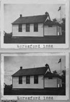
Gallery | Cupar and District Heritage Museum Schoolhouse Images

Thank you for stopping by #
Web Page title:
URL:
Copyright © Web Publish Date: All Rights Reserved
Saskatchewan One Room School House Project (SK ORSH)
Yorkton Gen Web Region
Regina Gen Web Region
School District Maps for these schools
1924 Railway Map for these place names; Township 20-27, Range 12-20, West of the Second Meridian

E-mail Webmaster ... Important Notice - Submitter

Bibliography:
1. From: Elaine Pain at Cupar and District Heritage Museum, P.O. Box 164, Cupar, SK, S0G 0Y0
To:Julia Adamson SK ORSH webmaster
Subject: Cupar and District School Photos