 | Cupar and District Heritage Museum One Room Schoolhouse Photos South East area of the province of Saskatchewan (SK), Canada (CA) |
 |
Click on image for larger size
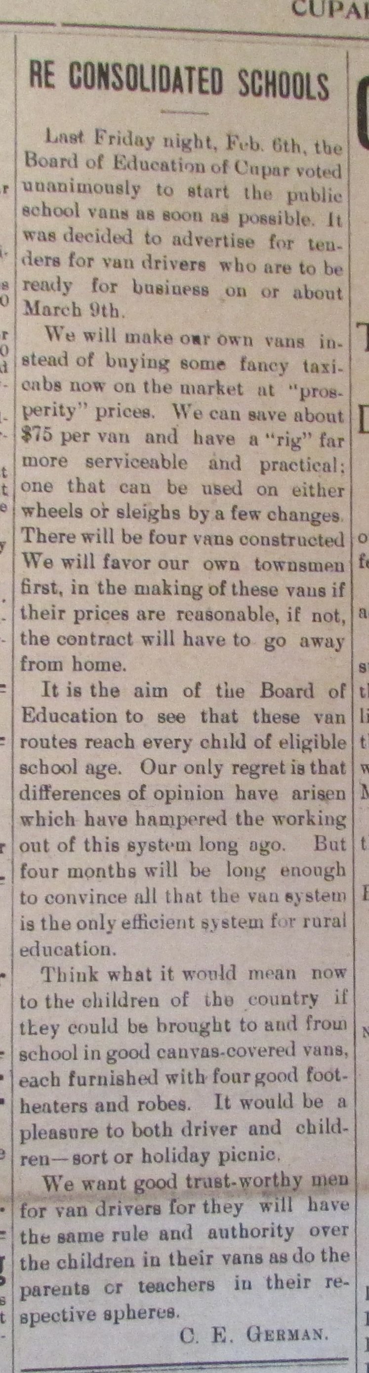
Cupar Town Location 8-23-16-W2,Province Saskatchewan, Latitude - Longitude DMS 50° 56' 48" N, 104° 12' 39'' W, Latitude - Longitude (decimal) 50.9466583, -104.2109556. Cupar and District Heritage Museum One Room Schoolhouse Photos School listing from Cupar and District Heritage Museum Schoolhouse Images "../images/ch%2012feb14%20purchase%20sch%20vans%2001.jpg" Relevant Placename Listing (Towns, Villages) with legal land locations "../images/ch%2012feb14%20purchase%20sch%20vans%2001.jpg" Pertinent Rural Municipalities "../images/ch%2012feb14%20purchase%20sch%20vans%2001.jpg" School District Maps for this school listing with legal land locations 1924 Railway Map showing Township 20-27, Range 12-20, West of the Second Meridian Legal Land Description: Township, Range, Meridian Information For more information: Local History Books "../images/ch%2012feb14%20purchase%20sch%20vans%2001.jpg" |
| Gallery | | | Cupar and District Heritage Museum Schoolhouse Images |
Thank you for stopping by #
Web Page title:
URL:
Copyright © Web Publish Date: All Rights Reserved
Saskatchewan One Room School House Project (SK ORSH)
Yorkton Gen Web Region
Regina Gen Web Region
E-mail Webmaster ... Important Notice - Submitter
Bibliography:
1. From: Elaine Pain at Cupar and District Heritage Museum, P.O. Box 164, Cupar, SK, S0G 0Y0
To:Julia Adamson SK ORSH webmaster
Subject: Cupar and District School Photos ![]()