 Online Historical Map Digitization Project |
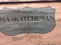
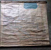
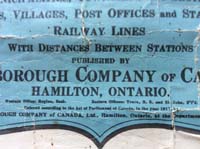
| . 1917 "Scarboroughs New Map of Saskatchewan" Province of Saskatchewan, Canada Digitally submitted by Dysart and District Museum Dedication (The Scarborough Company of Canada, Ltd.Hamilton, Ontario.Western Office, Regina, Sask. Eastern Office, Truro N.B. and St. John N'F'd.) or does anyone have suggestions as to where search. |
 |
 |
 |
 |
 |
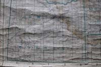
IMG_3897.jpg
West of the 3rd meridian. Swift Current area South west portion of the Province of Saskatchewan |
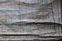
IMG_3898.jpg
West of the second meridian Township 1 to 18 Range 1 to 6 West of the third meridian around and south of Regina South Middle Portion |
IMG_3899.jpg
West of the first meridian Township 1 to 15 Range 1 to 19 West of the second meridian Weyburn area South East Portion |
IMG_3900.jpg
West of the first meridian Township 15 - 33 Range 1 - 19 West of the second meridian Kamsack area Central East Portion |
IMG_3901.jpg
West of the 3 meridian Township 14 - 40 Range 1- 23 West of the 2 meridian South of Saskatoon to North of Regina Central Middle Portion |
 |
 |
 |
 |
 |
IMG_3902.jpg
West of the 3 meridian South west of Saskatoon Central West Portion |
IMG_3903.jpg
West of the 1 meridian Township 32 - 56 Range 1 -32 West of the 2 meridian Prince Albert area North East Portion |
IMG_3904.jpg
West of the 3 meridian Lloydminster area North West Portion |
IMG_3905.jpg Legend |
IMG_3906.jpg
West of the 3 meridian Meadow Lake area North North West Portion |
 |
 |
 |
 |
 |
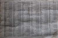
| IMG_3907.jpg Abbey to Fillmore . |
IMG_3908.jpg Findlater to Mulock S 4-28-1 W2 alphabetically. |
IMG_3909.jpg Leinan S12 T18 R14 W3 Leipzig S20 T37 R19 W3 to Mullraney S3 T 6 R 29 W2 Mulock S4 T 28 R1 W2 |
IMG_3910.jpg Prussia to Zumbro |
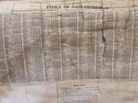
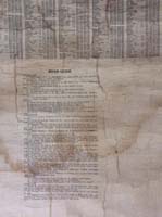
IMG_3911.jpg ROAD GUIDE |
EXPLANATION:Figures in parenthesis give population in accordance with the latest Census. C.N. = Canadian Northern Ry. C.P. Canadian Pacific Ry. G.T. = Grand Trunk Pacific. S.=Section. T.=Township. R.= Range W=West of Meridian | ||||
 |
 |
 |
 |
 |
| image2.jpg LEGEND |
image3.jpg FULL VIEW OF MAP |
image3 a.jpg FULL VIEW OF MAP |
image4.jpg LEGEND CLOSE UP |
image5.jpg LEGEND |
 |
 |
 |
 |
 |
| image6.jpg Findlater to Paddockwood |
image6-twice.jpg Findlater to Paddockwood |
image7.jpg Lacordiare - Leigh Luxton-Marconi Millerdale - Mulock Nutana - Paddockwood ROAD GUIDE |
image7-twice.jpg Lacordiare - Leigh Luxton-Marconi Millerdale - Mulock Nutana - Paddockwood ROAD GUIDE |
image8.jpg
Moosomin Cannington Estevan |
 |
||||
image8twice.jpg
Moosomin Cannington Estevan |
||||
How to use 1917 Scarborough Maps. A legend. Use township numbers for the north and south finding aid. Use range numbers for east and west. The meridians for each map segment are supplied on the table on this page.  More about township and ranges
|

|
Welcome to a new chapter in history! The Online Historical Map Digitization project volunteers extend a warm invitation to our new domain at https://saskgenweb.ca/canmaps/. We are thrilled to persist in our passion for documenting Saskatchewan's rich genealogy, history, family stories, community heritage, one-room schoolhouses, cemeteries, headstones, historical maps, and the myriad of vanished placenames. These resources are invaluable for those tracing their roots or seeking historical insights. With the support of our growing Patreon community at https://www.patreon.com/SaskGenWeb, we've secured a new domain and hosting to continue providing this service. Your contributions help us thrive year after year. Explore our evolving webpages at https://saskgenweb.ca/canmaps/ for the Online Historical Map Digitization project courtesy SaskGenWeb at https://saskgenweb.ca/cansk/.
Beyond this exciting announcement, we encourage visitors to consider supporting our volunteers through Patreon. The generosity of Ancestry.com and Rootsweb.com in providing free web hosting space has been invaluable. Now, as we transition to paid hosting, we seek your support in sustaining the Online Historical Map Digitization project. The previous site, hosted by Rootsweb and Ancestry, is evolving into a new, dynamic space at our fresh domain. Your presence, whether through memories of historical maps, one-room schoolhouses, cemetery headstones, transcriptions, yearbooks, directories, or historical letters, adds depth to the collective understanding of our shared heritage. Step into this new era with us, where your support, in any form, is a cherished gift to the history that unites us all. Together, we embark on a journey to continue preserving and celebrating the rich history of the Online Historical Map Digitization project. |