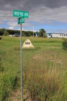
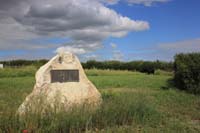
 | Tyrone School District 4608 1925-1958 Wilton Rural Municipality 472 9.8 kilometers to Trans Canada Highway 16 west 9.8 kilometers to Saskatchewan highway 675 Township road 474, Range road 326 Southwest section 26 Township 47 range 26 West of the third meridian near Lashburn, Saskatchewan |
 |
 |
 |
 |
 |
 |
 |
 |
Using the township range signs which were located near this schoolhouse sign, this marker is located near the intersection of Twp Rd 474 and Rge Rd 3262. The first number of the Range Road is the meridian and the next numbers are the range number (incrementing every 6 miles west of the meridian to demark the east and west borders of a township). The last number is how many miles the range road is from the eastern edge of the range, or the eastern border of the 6 miles by 6 miles township. This sign indicates that this plaque is west of the third meridian, in range 26 and 0 miles from the eastern border of the township. The township sign indicates that the intersection of the north west range road and the east west township road is located in township 47 and 4 miles north of southern edge of the township. So the intersection is located in township 47, range 26 west of the third meridian, and the section would be 2 miles from the eastern border of the township, and 4 miles north of the southern border. Examining the layout of sections and their numbers, this would make the intersection near quarter 24 Tsp 47 Rge 26 W3 and the schoolhouse has been recorded by Bill Barry at SW Sec 26 Tsp 47 Rge 26 W of the 3 Meridian near Lashburn, Saskatchewan. This plaque is located near these placenames hamlet of Lone Rock located at section 15- township 47- range 27-West of the 3rd meridian Latitude - Longitude 53º 3' 00'' N, 109º 52' 44'' W OR 53.0499722, -109.8788749 town of Lashburn located at section 8- township 48-range 25-West of the 3rd meridian Latitude - Longitude : 53º 7' 31'' N, 109º 36' 48'' W OR 53.1251499, -109.6132750 village of Marshall located at township 49 - range 26-West of the 3rd meridian Latitude - Longitude : 53º 11' 27'' N, 109º 46' 47'' W Or 53.1906972, -109.7796527 village of Waseca located at 32-47-24-W3 Latitude - Longitude : 53º 5' 58'' N, 109º 28' 24'' W OR 53.0993749, -109.4733027 Freemont is an unincorporated area at section 31- township 44- range 24-W3 Latitude - Longitude : 52º 50' N, 109º 30' W OR 52.8334106, -109.5007466 Unity is a town at section 18- township 40- range 22-W3 Latitude - Longitude : 52º 26' 32'' N, 109º 9' 27'' W OR 52.4421250, -109.1574916 Neilburg is a village at section 31- township 44- range 25-W3 Latitude - Longitude : 52º 50' 22'' N, 109º 37' 39'' W OR 52.8394028, -109.6276278 unincorporated area of Buzzard unincorporated area of Epping unincorporated area of Furness unincorporated are of Nunebor unincorporated area of Ridgeclough, Alberta unincorporated area of Rivercourse, Alberta unincorporated area of Southminster unincorporated area of Unwin Wycollar located at section 4- township 46-range 26-W3 Latitude - Longitude : 52º 56' N, 109º 44' W OR: 52.9334121, -109.7340937 84 As a side note the two unincorporated areas were a part of the District of Saskatchewan, Northwest Territories before 1905, however this school district may have formed after 1912 as it is not noted on the one room school district map which is attached. One Room School District Maps Historical Railway Maps of Saskatchewan |
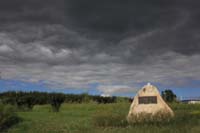
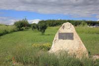
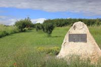
| Gallery |
Thank you for stopping by #
Web Page title:
URL:
Copyright © Web Publish Date: All Rights Reserved
Saskatchewan One Room School House Project
Lloydminster Gen Web Region
E-mail Webmaster ... Important Notice - Submitter
Bibliography:
1.
Photographs copyright Julia Adamson ORSH webmaster
Subject: Tyrone one room schoolhouse 4608, Saskatchewan
Date July 30, 2013
![]()