 | Senlac Community Senlac Church, Community of Christ, Senlac, 32-40-26-W3, Latitude - Longitude : 52º 29' 35'' N, 109º 42' 30'' W, Latitude - Longitude 52.4931361, -109.7082360, Senlac Rural Municipality No. 411, |
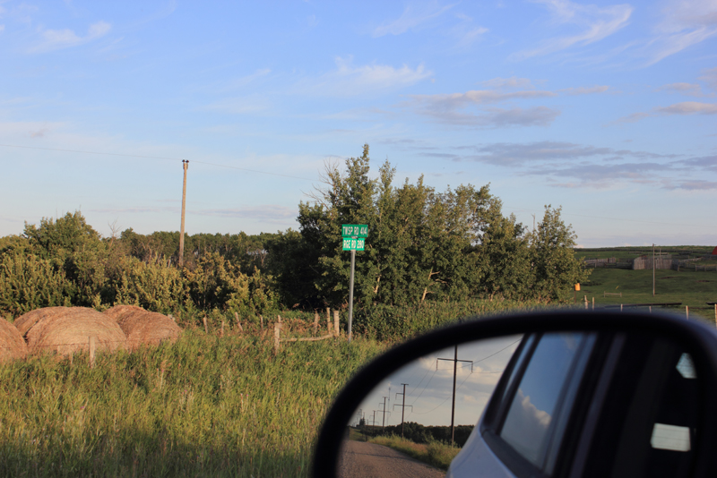 |
Using the township range signs which were located near the building photographed (not the Community of Christ building) this marker is located near the intersection of Twp Rd 414 and Rge Rd 280. The first number of the Range Road is the meridian and the next numbers are the range number (incrementing every 6 miles west of the meridian to demark the east and west borders of a township). The last number is how many miles the range road is from the eastern edge of the range, or the eastern border of the 6 miles by 6 miles township. This sign indicates that this plaque is west of the third meridian, in range 28 and 0 miles from the eastern border of the township. The township sign indicates that the intersection of the north west range road and the east west township road is located in township 41 and 4 miles north of southern edge of the township. So the intersection is located in township 41, range 28 west of the third meridian, and the section would be 0 miles from the eastern border of the township, and 4 miles north of the southern border. Examining the layout of sections and their numbers, this would make the intersection near section 24 Tsp 41 Rge 28 W3 and the NORTH END School District # 2650 has been recorded at Sec Tsp 41 Rge 28 W of the 3 Meridian near (Macklin P.O. Twp.39, R.28, W3 66) 65 and 66 (The Listing compiled at the Provincial Saskatchewan Archives Regina Branch and Library and Archives Canada Exploration and Settlement > Western Land Grants (1870-1930) ). The North End Book Club in the book Along the North End Trail places North End School # 2650 on the southeast quarter section of 28 near Evesham, and Bill Barry puts the post office of North End at Northwest 32 section 40 range 28 west of the 3rd meridian. North End School District 2650 school house was erected in 1910 and opened under Miss Keane, the first teacher. North End closed in 1962, and the building used by the community. North End School District 2650 is located along Saskatchewan Highway 17 thirteen km north of the Saskatchewan Highway 14 (Unity) ~ Saskatchewan Highway 31 (Kerrobert) intersection north of Macklin where the junction of 14 and 31 meets Saskatchewan Highway 17. North End School District 2650 is marked with a schoolhouse sign at that location. SENLAC School District # 2749 was located at SW Section 5 Tsp 41 Rge 26 W of the 3 Meridian near Senlac, Saskatchewan. One Room School District Maps Historical Railway Maps of Saskatchewan |
| Gallery |
Thank you for stopping by #
Web Page title:
URL:
Copyright © Web Publish Date: All Rights Reserved
Saskatchewan One Room School House Project
Battleford Gen Web Region
E-mail Webmaster ... Important Notice - Submitter
Bibliography:
1.
Photographs copyright Julia Adamson ORSH webmaster
Date July 30, 2013
![]()