
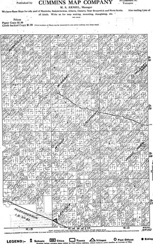
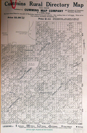
| Legend. Scale and symbols used on Cummins maps. (Click on above image for larger size) | |
 | Map 1 Cummins Map Company Includes Gainsborough, Carievale, Carnduff, Glen Ewen, Oxbow. Township 1 and 2 Ranges 30, 31, 32 West of the First or Prime Meridian, Map 1 from 1920-- East side of map Map 1 from 1920-- West side of map |
| Dedication | |
 | Map 2 Cummins Map Company Includes Gainsborough, Carievale, Carnduff, Glen Ewen, Oxbow. Township 1 and 2 Ranges 30, 31, 32 West of the First or Prime Meridian, Map 2 from 1920-- East side of map Map 2 from 1920-- Middle segment of map Map 2 from 1920-- West side of map |
| Dedication | |
 | Map 91 Cummins Map Company Includes Clavet, Nutana, Dundurn, Saskatoon, Floral, Asquith, Eston, Vanscoy, Dalmeny, Aberdeen, Sutherland, Langham, Clark's Crossing, Warman, Clarkboro, Cory, Egnen, Hawker, Grasswood, Farley. Townships 35, 36, 37, 38 Ranges 4, 5, 6 West of the Third Meridian, |
| Dedication | |
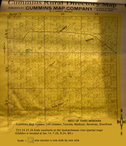 | Map 144 Cummins Map Company Township 23 24 25 26 Range 22 23 24 West of the third meridian Ends southerly at the Saskatchewan river (partial maps only) Glidden, Tuscola, Madison, Noremac, Riverfront (Glidden is located at SW 27 T.25 R.24 W3, however was first located at section 14 T.26 R.24 W3, its former name was Holbeck ) (Noremac NW Sec. 34 T. 25 R.22 W3) (Tuscola t SW 16 T. 25 R.23 W3) (Riverfront NW 16 T.24 R.23 W3) |
 |
Map 147 Cummins Map Company Township 28 29 30 Range 30 31 32 33 W1 Togo, Kamsack, Canora, Runnymede, Calder, Veregin, Stornoway, Wroxton, Mulock, |
 |
Map 148 Cummins Map Company Tsp 27 28 29 30 Rge 1 2 3 W2 Map 148 Includes: Canora, Donwell, Mikado, Gorlitz, Ebenezer, Hamton, Kamsack, Veregin, Rhein, Burgis, Yorkton, Stornoway Map 148 from 1920-- bottom of map Tsp 27-28 Rge 1 2 3 W2 Map 148 from 1920-- middle of map Tsp 28-29 Rge 1 2 3 W2 Map 148 from 1920-- top of map Tsp 29-30 Rge 1 2 3 W2 |
 | Map 149 Cummins Map Company Includes Ebenezer, Yorkton, Orcadia, Springside, Lenman, Theodore, Beaverdale, Willowbrook, Gorlitz, Canora, Ebenezer Valley, Whitesand, Burgis, Drobot, Tiny, Buchanan, Devil's Lake 1920 Map, Township 27 28 29 30 Ranges 4 5 6 West of the second meridian Map 149 from 1920-- bottom of map Tsp 27-28 Ranges 4 5 6 West of the second meridian Map 149 from 1920-- middle of map Tsp 28-29 Ranges 4 5 6 West of the second meridian Map 149 from 1920-- top of map Tsp 29-30 Ranges 4 5 6 West of the second meridian |
| Dedication | |
 |
No. 152 Cummins Map Company Tsp 27, 28, 29,30 Rge 13, 14, 15 West of the 2nd Meridian: Rushville, Wishart, Mozart, Wynyard, Elfros, Leslie, Ladstock, Mildnay Park, Punnichy, Wynot, Lestock, Foam Lake, Model Farm, Leross, Kelliher, Edmore |
| Dedication | |
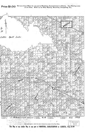
 | No. 164 Cummins Map Company Tsp 27, 28, 29,30 Rge 13, 14, 15 West of the 2nd meridian: Beadle, Netherhill, Brock, D'Arcy, Madison, Eston, Snipe Lake, McMorran, Penkill, Richlea |
| Dedication | |
 |
Map No. 173 Cummins Map Company Tsp 31, 32, 33, 34 Rge 14, 15, 16 West of the 2nd Meridian Wadena, Fishing Lake, Paswegin, Clair, Elfros, Mozart, Lelsie, Wynyard, Kristnes, Rushville |
| Dedication | |

|
Map No. 173 Cummins Map Company Tsp 31, 32, 33, 34 Rge 13, 14, 15, West of the 2nd Meridian: Paswegin, Clair, Wadena (SE 1/4 Sec.29, Twp.34, R.13, W2 - 1933-03-31), Elfros, Mozart, Wynyard, Fishing Lake, Haglof (Sec.32, Twp.31, R.14, W2 ), Kristnes, Leslie, Rushville, Holar |
| Dedication | |
 | Cummins Map Company, 1920 Map, Townships 35, 36, 37, 38 Ranges 4, 5, 6 West of the Third Meridian, Clavet, Nutana, Dundurn, Saskatoon, Floral, Asquith, Eston, Vanscoy, Dalmeny, Aberdeen, Sutherland, Langham, Clark's Crossing, Warman, Clarkboro, Cory, Egnen, Hawker, Grasswood, Farley, |
| Dedication | |
 |
Map No. 217 Cummins Map Company Township 39, 40, 41, 42A, 42 Range 1, 2, 3 West of the Third Meridian: Map 217 states it includes: Rosthern, Hague, Aberdeen, Osler, Vonda, Aberdeen, Alvena, St. Julien, Clarkboro, Sokal, Fish Creek, Saskatchewan |
 | Map 235, Tsp 43 44 Ranges 7 8 9 West of the Third Meridian, Bottom Section Tallman, Redberry Map 235 states it includes: Krydor, Windsor Lake, Blaine Lake, Hafford, Albertown, Redberry, Klezckowski, Springbourne, Petrofka, Aldina, Marcelin, Moon Lake, Chellwood, North Battleford |
 | Map 267, Tsp 51, 52, 53, 54 Ranges 25, 26, 27 West of the Third Meridian Map 267 (1922) states it includes: Lloydminster, Hewitt Landing, Rex, Greenstreet, Tangle Flags, Marshall, Northminster, Fort Pitt, Monnery, Onion Lake, Harlan |
| Dedication | |
 | Map 267, Tsp 51, 52, 53, 54 Ranges 25, 26, 27 West of the Third Meridian Map 267 (1922) states it includes: Lloydminster, Tangleflags, Hewitt Landing, Rex, Northminster, Paradise Hill, Ashley, Fort Pitt, Red Cross, Edmonton, Harlan, Greenstreet, Monnery |
| Dedication | |
 | Map 267, Tsp 51, 52, 53, 54 Ranges 25, 26, 27 West of the Third Meridian Map 267 (1930) states it includes: Lloydminster, Tangleflags, Greenstreet, Ashley, Hewitt Landing, Rex, Northminster, Twin Lakes, Leighton, Alberta, Fort Pitt, Harlan, Red Cross, Frenchman Butte, Hillmond, Paradise Hill |
| Dedication | |
 | Here (preview click for large size) is the map of Saskatchewan marked with townships and ranges, and sectioned off into the various Cummins Maps with their corresponding map number. If you don't see a map online, Contact the Archives of Saskatchewan with the Map number and year (ie 1920, 1922, 1926, or 1930) verify the township and range, and meridian or placename - city, town, hamlet - corresponding to the Cummins Map number you would be seeking to find....The Archives collection call number would be A/3. Let the archives know if you would like a print out copy or a digital copy emailed ..... The archives does not have every single map - there are gaps in the maps existing at the archives for the various years, however one can check with an enquiry to see if the desired map number and the corresponding year would be available. |
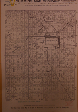
Tutorial: How to read Homestead Records- Section, Township, Range, MeridianBrief Introduction to Legal Land Locations -Tsp and Rge: presented below: The larger the TSP township number the further north. West of the 3 meridian and the higher the RGE range number, the closer to the Alberta border West of the 1st or prime meridian with the smaller the range number the closer to the Manitoba border West of the 2nd meridian in the center of the province, the higher the range number, the further west. For example these cities are located at: Saskatoon Tsp 36 Rge 5 W of the 3rd Meridian Regina Tsp 17 Rge 19 W of the 2nd Meridian | |
Web Publish (
|
 ............ ............ Home............ Home............ Sign Guestbook Sign Guestbook |