 Index Online Historical Map Digitization Project Index Online Historical Map Digitization Project |  Home 1954 SGI Map Home 1954 SGI Map |

Alphabetical Placenames Index "map key"
 |
 |
 |
 |
 |
 |
 |
 |
 |
 |

|

|

|

|

|

|

|
 |
 |

|

|

|

|

|

|

|
 |
 |

|

|

|

|

|
|

|
 |
 |

|

|

|

|

|

|

|
 |
 |
 |
 |
 |
 |
 |
 |
 |
 |
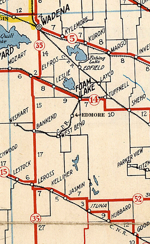
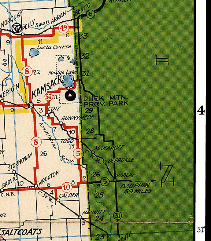
The map is also defined by legal land location and latitude and longitude. NOTICE: This is an historical highway map when the highways were still "on the square," following the one-square-mile (2.6 km2) sections of the Dominion Land Survey. In the late 1950s and 1960s, the main thoroughfare highways were paved, straightened and widened. The numbering of the highways in 1954 is also not in direct correspondence with highway numbers in existenece now. For example Provincial Highway 5, the Evergreen Route, was the precursor of the contemporary Yellowhead Saskatchewan Highway 16 between Saskatoon and the Alberta provincial boundary at Lloydminster as the highway followed the surveyed grade of the Canadian Northern Railway, later the Canadian National Railway line. Provincial Highway 14, between the Manitoba boundary and Saskatoon was the precursor of the Yellowhead Saskatchewan Highway 16 for the eastern portion of the route following the surveyed grade of the Manitoba and North West railway, later the Canadian Pacific Rrailway. Whereas, historically highways were named Provincial highways, and designated as numbers within circles, on contemporary maps, Saskatchewan highways are designated within a crest as in this Saskatchewan map The Territorial Dept. of Public Works administered to all public works until Local Improvement Districts were created in 1904 replacing Fire Districts, Statute Labour and Fire (SLF) Districts or Statute Labour Districts. Local improvement districts themselves gave way to the current form of municipal government, city and town city halls and Rural Municipalities. Roads and highways received improvements under joint funding Provincial and Municipal road programs. The first Department of Highways in Saskatchewan was established in 1917, this title changed to the Department of Highways and Transportation on September 1, 1934 another renaming occurred on November 21, 2007, becoming the Ministry of Highways and Infrastructure. Bus routes are marked in yellow on this provincial map for the Saskatchewan Transportation Company (STC) The STC had been a Crown Corporation of the Government of Saskatchewan serving the rural population. STC created in 1946 by an Order in Council carrying freight and passengers, and closing for freight May 19, 2017, and closing for passengers May 31, 2017. The 1920s saw the largest rise in rail line track as the CPR and CNR fell into competition to provide rail service within ten kilometres ( See 1925 Waghorn's Railway Guide and Map for comparison.) By the 1960s there were applications for abandonment of branch lines. As of 2017 twelve ferries are still operational. Estuary, Lemsford, Lancer, Riverhurst, Clarkboro, Hague, St. Laurent, Fenton, Weldon, Paynton, Wingard, Cecil, and Wollaston Barge This map shows places no longer in existence. For example Nutana and Sutherland show as distinct placenames on this map, whereas now these locations are neighbourhoods in the city of Saskatoon. South of Saskatoon enroute to Dundurn, are labelled Strehlow, and Haultain which are further examples of placenames no longer in existence, and commemorated by roads named in their honour. There are other historic placenames which are no longer in existence which may be of help to genealogists or historians referencing an historic document or locality. Compare to 1926 Saskatchewan Highway Map Copyright: November 25 2017 Email: saskgenweb@yahoo.com Webmaster Julia Adamson Sign Guestbook View Guestbook saskgenweb.ca/canmaps/1954SGI/ We encourage links to this page saskgenweb.ca/canmaps/1954SGI/ Saskatchewan Government Insurance Highway Map of Saskatchewan issued in cooperation with the Department of Highways and Transportation. Canada. 1954. This web site was made with possible with the original scan from Larry Walton. It is the intention of this site to make Saskatchewan town names and locations as of 1954 available to persons with a historical or genealogical interest in this area. There are no service charges or fees for personal use of this map service, and use of this site constitutes your acceptance of these Conditions of Use. This page is dedicated to the free sharing of this Saskatchewan historical data for personal use, any online or commercial re-publication requires permissions. Any further use of these maps would require permission from the contributor Larry Walton as per copyright laws in Canada. Dedication Webmaster: saskgenweb@yahoo.com NEW EMAIL saskgenweb@yahoo.com |